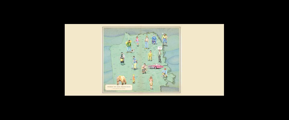


For years, Darin Jensen ’99, lecturer and staff cartographer in UC Berkeley’s Geography Department, has taught his students to create neighborhood maps that don’t merely identify the streets and avenues, hills and creeks where they live, but capture the quality of life that is lived there. Students would take to the streets in search of “dominating social and cultural institutions” such as churches, health clinics, art, parks, and ethnic groceries. Each map was to depict one or two of those elements, to look at each element in isolation. In 2012, he assembled a team of student cartographers to take these “socially conscious” maps, as he called them, and they put together an atlas of a prominent area—San Francisco’s Mission District.
Now Jensen is at it again, this time in his own hometown. He is mapping International Boulevard in Oakland, the city he’s called home for 30 years. International Boulevard spans 107 blocks, from downtown to the city’s border with San Leandro. The Boulevard cuts through several Oakland neighborhoods, including Eastlake, San Antonio, Fruitvale, and East Oakland. He sees the city undergoing a transition, possibly a renaissance, and thinks that an atlas charting International Boulevard, a culturally and racially diverse landscape abounding in houses of worship, ethnic restaurants and shops, playgrounds, pink houses, and public art will serve as a snapshot of a changing Oakland.
“It’s a beloved city for me,” he said. “I think it’s really valuable to document the Oakland of 2015. It’s interesting today and it will be interesting far into the future as well.”
Recent UC Berkeley graduate Jake Rosen, who started working on the project last fall while he was enrolled in Jensen’s course, created a map of street art along International Boulevard. He learned about a neighborhood’s value of sports franchises when he had a conversation with a man about a mural portraying all of Oakland’s sports teams. The man lived near the Oakland Coliseum, home of the Oakland Athletics, the Golden State Warriors and the Oakland Raiders.
“It’s so easy to feel neglected in East Oakland but to have these teams … means a lot to [this man and members of his community]” Rosen said. “Identity can be really rooted in place.” The neighbors really appreciate “the proximity to these teams” and the fact that they are “playing for the fans.”
The project aims to create an alternative to the dominant narrative of East Oakland, which is often negative.
“There’s a lot of controversy with these underserved neighborhoods so it’s important as a learning technique to take what we hear in the media with a grain of salt,” said recent UC Berkeley graduate Sasha Helton, who has been working on the project since the fall. “There are a lot of things going on under the surface, so having an opportunity to go in and see the hidden narratives alongside the dominant narratives is so important.”
To create these maps, Jensen and his team combine poster art, infographics and journalism. Their work includes gathering data in the field, which can include going door-to-door to identify the cultural identity of pink houses and local businesses, as well as combing through government documents such as the census and transit maps. These cartographers then design the maps on the computer, and write explanatory text.
“The purpose of a map is to tell a story,” Jensen said. “Maps carry a narrative. It’s not just the mechanics of ‘can you find data and can you put data points on areas of a map’ but it’s also ‘how can you use graphic design concepts to tell a story through a map.’”
His own project, mapping the location of pink houses, serves as a counter narrative to the idea of certain crime-heavy, low-income neighborhoods being depressed and hopeless, according to Jensen. By mapping them, he can see if the houses are more prevalent in certain areas or clustered together, and if it is the latter, if one house begets another.
To help tell the unique and diverse stories of International Boulevard, many cartographers visited the area and interviewed residents, noted locations of their map’s subject, such as taco trucks or beauty shops, and took pictures of their surroundings to accompany the map.
While they were collecting stories, Jensen said he and his team had many memorable experiences and forged strong relationships.
“While we are mapping a community we become a community,” he said. “These projects have built long-lasting friendships between me and some of my students.”
One particularly memorable experience, Jensen says, was the day he, his young daughter, and one of his students piled into the student’s car to hunt for all the pink houses along International Boulevard, which was his daughter’s idea.
“It was a really fun day,” he said. “My daughter got to be with this college student and my student got to be with this young girl who had this cool idea. It was an intergenerational experience for all of us.”
While team members have enjoyed collecting data in the field, their role as outsiders looking in has not been lost on them. They plan to host a public forum to gain feedback from members of the communities along International Boulevard.
“It’s hard to make an atlas of a place I know nothing about,” Rosen said. “I wouldn’t feel very comfortable publishing the atlas if we didn’t get feedback from the community.”
Once the atlas is published, copies of the book will be donated to schools and libraries in East Oakland, thanks to UC Berkeley’s crowd-funding platform. Although the University gave the project sufficient funding to create the maps and publish them online, Jensen says he didn’t even try to raise the additional money necessary for printing. So when Berkeley Crowdfunding approached him, he welcomed the opportunity to solicit help on their website.
Jensen says that being able to give maps back to the community is a really important part of the project.