


UC Berkeley researchers have cautioned for some time that climate change-driven sea level rise will inundate much of the Bay Area’s low-lying regions, but a new study indicates the threat is particularly acute for landfill developments such as Treasure Island and Foster City.
The study, published this week in the journal Science Advances by researchers at Berkeley and Arizona State University, was based on data collected via satellite-based synthetic aperture radar (inSAR) and GPS monitoring from 2011 to 2017. Researchers used the information to pinpoint the areas around San Francisco Bay that will be most susceptible to rising seas. What clearly stuck out, said senior author and Berkeley professor of earth and planetary science Roland Bürgmann, is the vulnerability of landfill zones, which are sinking due to soil compaction, and at a rather alarming rate. That means the edifices and roadways built on them face a double whammy—they’re going down even as sea level is coming up.
“We found that they’re sinking as much as one-half inch (12.7 millimeters) annually,” says Bürgmann. “Sea level rise, by contrast, is on the order of one to three millimeters per year.”
Earlier studies on the vulnerable San Francisco Bay shoreline did not take land subsidence into account, and pegged areas likely to be flooded by 2100 at 20 to 160 square miles. The new maps generated by Bürgmann and co-author Manoochehr Shirzaei of ASU identify 48 to 166 square miles as prone to inundation.
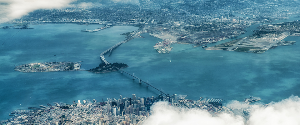
Half of San Francisco International Airport’s runways could be underwater by the turn of the century.
The technology the researchers employed will likely change the way risks related to sea level rise are calculated. InSAR allows precise measurements down to the level of a single millimeter from earth’s orbit. Bürgmann has employed inSAR data to map Berkeley landslides and land subsidence in Santa Clara County, but evaluating sea level rise is a new application of the technology.
The findings are particularly dire for specific developments around San Francisco Bay. Treasure Island, constructed north of the Bay Bridge from fill reclaimed from the 1939 Golden Gate Exposition, is now the site of an ambitious redevelopment project. As many as 8,000 new—and much needed—homes may be built here. But the island is subsiding dramatically, up to 20 mm a year in places.
“The northwest corner in particular is experiencing significant subsidence,” says Bürgmann.
Other vulnerable infill areas include the sprawling development of Foster City on the western terminus of the San Mateo-Hayward Bridge. It could experience significant flooding by 2100, says Bürgmann. San Francisco International Airport, already threatened by sea level rise, likewise is sinking: half its runways could be underwater by the turn of the century.
Landfill compaction isn’t the only cause of land subsidence in the Bay Area, Bürgmann says. “River and stream outflows into the bay deposit a lot of silt and mud,” says Bürgmann, “and we’ve found these areas also are subsiding as they become compacted and dry out.”
Another major contributor to land subsidence is groundwater pumping, says Bürgmann – but that, at least, is a factor that can be addressed with some efficacy.
“In the early 20th Century, Santa Clara County depleted its aquifers so much that there was subsidence up to several meters in some areas,” Bürgmann says. “They had major flooding, and the Santa Clara Water District responded with tough regulation that has basically remained in place to this day. They were actually able to turn things around by carefully managing their aquifers [through pumping restrictions and groundwater recharge], to the point that we actually saw ground levels rise through the last drought.”
A few years ago, many scientists opined that sea level rise might be no more than 1.5 feet by 2100. Those estimates are now disputed, given that ice sheets in Greenland and western Antarctica are melting at a faster rate than expected. More recent estimates predict sea levels as high as 5.5 feet by 2100. Land subsidence at the high end of these estimates plays less of a role in potential flooding than at the low end, Bürgmann acknowledges, but the new information strongly indicates land subsidence should be considered in future Bay Area flood response planning.
“Further, our work just addressed average sea level rise,” Bürgmann says. “We also need to consider the impacts of such things as king tides and 100-year storms. With sea level rise and subsidence combined, the effects of those kinds of events can be greatly magnified.”
Though the study was restricted to San Francisco Bay, Bürgmann observes the inSAR model could be applied to any region where sea level rise is a concern.
“You look at places like Bangladesh, Jakarta—sea level rise is a critical issue,” Bürgmann says. “Our approach allows for refined and accurate assessment, and that can help drive rational responses.”