


On May 29, 2006, residents in the Porong subdistrict of Sidoarjo, East Java, awoke to a strange rumbling and emerged from their homes to find a geyser of mud shooting 26 feet in the air. In the days that followed, more cavities opened in the ground, and the bowels of the earth came spilling out. The air was rank with the odor of hydrogen sulfide. Within months, a square mile was submerged in sludge, including rice paddies, shrimp ponds, and entire villages.
The Lusi mud volcano—the name is a contraction of lumpur (meaning “mud”) and Sidoarjo—caused thousands of Indonesians to evacuate their homes, and left scientists puzzling over its origins.
Mud volcanoes occur when subterranean liquid is under enough pressure to erupt to the surface. Many examples are found underwater, as in the Gulf of Mexico, where the Mississippi River deposits sediment so rapidly that fluid becomes trapped and is compressed until finally it forces its way through the sea floor.
Earthquakes, of which Indonesia has plenty, can cause mud volcanoes when seismic shaking releases water trapped underground. Just two days before Lusi’s eruption, a 6.3 magnitude quake shook Java, killing almost 6,000 people and leaving over half a million homeless. The epicenter was near Yogyakarta, about 160 miles from Lusi. Far closer to Lusi was a gas-drilling operation where a well had been driven to a depth of almost two miles. While Lapindo Brantas, the company drilling the gas well, pointed to the earthquake as the cause of the eruption, a team of British geologists suspected that in fact the well was the culprit. In making their respective cases, both sides in the debate cited research by Berkeley geophysicist Michael Manga.
Sitting in his McCone Hall office, Manga laughs as he recounts being drawn into the distant controversy. “I thought, well, I wrote a paper, it’s got one number in it, one graph. It can’t tell two conflicting stories.” Manga swivels about in his chair as he talks. His shoes are left on the ground, his legs and feet drawn up under him. Large round eyes lend the MacArthur Fellow a look of boyish exuberance.
“Usually when something happens on the surface of the earth, you can see what you see on the surface, but you don’t know what’s going on below the ground,” says Manga. In this case, however, the drilling operation collected data on subterranean activity, “so we actually know exactly what the geological units are, and we know their properties. We even have samples of what the subsurface is like.” In other words, Lusi presented an unprecedented research opportunity.
To pursue it, Manga teamed up with British geologist Richard Davies and other international colleagues. The researchers first asked whether the earthquake could have triggered the volcano. “If an earthquake is located at some distance from the volcano, it’s got to be big enough to trigger the eruption. And as the earthquakes get bigger and bigger, they can be more distant and still cause an eruption.” In the case of the Yogyakarta quake, says Manga, “It looked like the earthquake was far too small, given how far away it was, to trigger the eruption.”
The team then turned to the drilling site. According to the company’s data, the day before the eruption, as the drill pulled out of the well, an infusion of fluids flooded the hole. The evidence suggests salt water and hydrogen sulfide gas moved in, increasing the well’s pressure and generating cracks in the surrounding rock. It is not exactly clear what caused the fluid to move into the well, but the dominant theory is that the drill penetrated pressurized limestone layers far below the surface.
“When you drill a well, you work very carefully to make sure that you control the pressure inside your drilling operation so that you don’t have the well collapse, or…generate new fractures,” Manga explains. To guard against those possibilities, drillers typically build steel casings around a well. But at the operation in question, casing protected only the top third of the borehole.
Ultimately, Manga and colleagues concluded that the earthquake did not trigger Lusi. Their findings point instead to a poorly executed drilling operation.
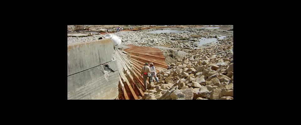
With one geophysical mystery solved, a monumental engineering challenge remains. Two and a half years after the eruption, mud continues to flow from Lusi at a rate of 196,000 cubic yards a day, and engineers from around the world have tried in vain to stanch the flow, even going so far as to drop hundreds of massive concrete balls into the crater in an attempt to plug the volcano.
“It’d be nice to be able to figure out when it’s going to stop,” says Manga. Unfortunately, that’s not an answer he can provide.