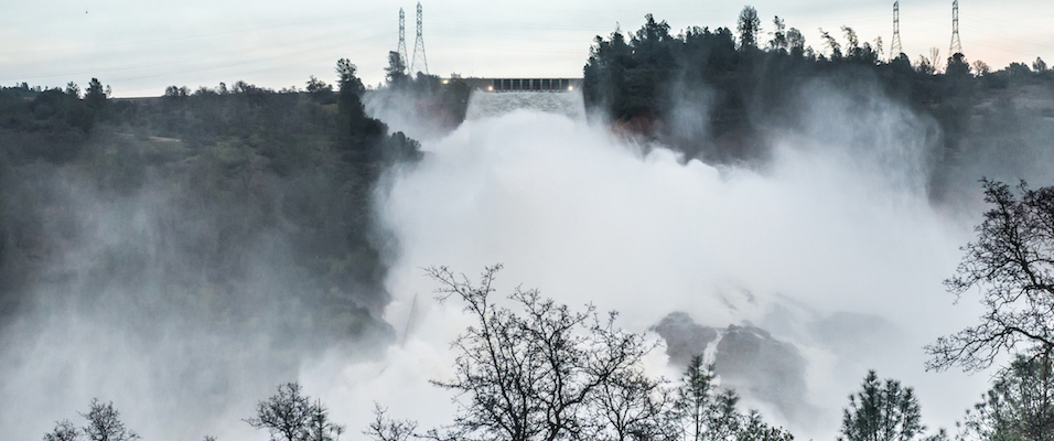


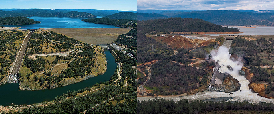
On February 12, 2017, nearly 200,000 Californians got the order to flee for their lives.
Record winter rains had filled Lake Oroville, the vast reservoir that anchors the California State Water Project, to the brim. To avoid overtopping, project managers had released massive quantities of water down Oroville Dam’s main spillway, but fissures in the concrete slabs that lined it were blown open by the torrents. The spillway was briefly closed to assess the newly formed crater, but repairs were impossible under the parlous conditions. The reservoir continued to rise, and water flowed over the wingwall atop the dam’s emergency spillway for the first time in the structure’s almost 50-year history. The slope below this auxiliary spillway was not lined with concrete and the hillside began eroding back toward the reservoir with alarming rapidity, threatening to undermine the wingwall.
The dam itself—at 770 feet high, the tallest in the country—was not at immediate risk. Collapse of the wingwall would be disaster enough, unleashing a 30-foot-high wall of water down the Feather and Sacramento Rivers, ultimately flooding large swaths of the city of Sacramento, blowing out levees in the Sacramento–San Joaquin Delta, and knocking out the gigantic pumps that send water to tens of millions of Southern Californians. Hundreds, maybe thousands of lives could be lost; the economic damage would spiral into the tens of billions of dollars or higher. The state’s electric grid could be impaired for months, and its water delivery infrastructure for years.
The evacuation of so many people downstream of the dam made national news, but few seemed to realize that the state was on the brink of a disaster that would have dwarfed the tragedy of Hurricane Katrina. As it happened, a break in the weather and ceaseless work by state Department of Water Resources (DWR) staffers prevented a catastrophe, but the incident revealed essential flaws in California’s water infrastructure.
Scientists concede that, even if we are fabulously successful at reducing emissions—and so far, CO2 levels continue to climb—concentrations of greenhouse gases in the atmosphere will increase for centuries to come. So, even as we struggle to wean ourselves off fossil fuel dependence, we will also have to adapt to its consequences.
Just as the five-year drought had made it clear that California’s reservoirs were unable to store sufficient water to see the state through extended dry spells, so did last winter’s record-setting precipitation highlight the obverse: Our dams and bypasses may not be adequate to prevent calamity during anomalously wet winters. That’s especially sobering because most computer models indicate that extreme weather—droughts and floods—will be part of California’s future as the climate changes. And a water storage and delivery system that more or less met needs from the 1950s to the 1960s, when the big dams and aqueducts were built, now seems lamentably inadequate in addressing the realities of the emergent geologic epoch: the Anthropocene.
Anthropocene is the voguish and not yet officially adopted term to describe the first geologic epoch in Earth’s history to be characterized primarily by the impacts of human activity, global warming foremost among them. To date, the societal response to climate change has mostly centered on efforts to reduce greenhouse gas emissions. But scientists concede that, even if we are fabulously successful at reducing emissions—and so far, CO2 levels continue to climb—concentrations of greenhouse gases in the atmosphere will increase for centuries to come. So, even as we struggle to wean ourselves off fossil fuel dependence, we will also have to adapt to its consequences.
Along with extreme weather events and climate swings, those consequences include rising sea levels, more and fiercer wildfires, and the rapid spread of vector-borne diseases. This winter’s crisis at Oroville was a disaster narrowly averted, but it should also be seen as a wake-up call of things to come.
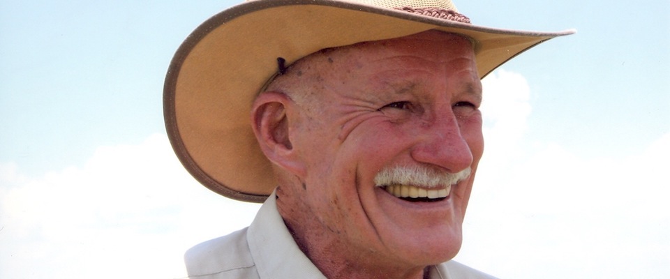
To get a better perspective on the situation, last March California accompanied Robert Bea, professor emeritus of civil engineering at Cal and a founding member of the University’s Center for Catastrophic Risk Management, on a tour of the dam site. Bea is often cited in the press as the nation’s foremost forensic engineer or, more waggishly, as the “Master of Disaster.” He specializes in assessing and managing risk in ambitious public and private works and in performing autopsies when infrastructure fails in spectacular fashion. He was a lead investigator in the Deepwater Horizon, Hurricane Katrina, and Challenger space shuttle disasters.

Now in his 80s, lean and bald with a steely glint in his eye, Bea has retained the animated movements and mordant wit of his younger years, although his speech is sometimes hampered by minor stuttering. “It’s a direct result of PTSD,” he says. “I’ve seen so much death and destruction resulting from poor choices that it sometimes affects my speech, particularly when I observe a situation where I see the same old mistakes being made.”
On the tour, wearing a hardhat and a safety vest, Bea surveyed Oroville Dam from across the tailwater below the spillway. The site, he said, had a hauntingly familiar feel about it.
“It’s the feeling I have whenever I go to any major failure,” he said. “The disaster hasn’t abated. Right now they’re just trying to get things pieced together well enough to take them through the spring snowmelt. But it’s clear to me they won’t be able to use the primary spillway again—or at least, they shouldn’t use it again. The best approach is to somehow incorporate that new canyon carved by the emergency releases into a new spillway. But that will be steeper, and put a whole new set of stresses on the system. You’d be basically trying to force a new design onto an old existing design, and that’s not a good idea in engineering, particularly when potentially catastrophic risks are involved.”
The biggest problem isn’t engineering. It’s human organization. Something bad happens, and people want to get back to ‘normal’ as soon as possible. So decisions are made that amount to quick fixes.
The repairs won’t happen overnight—or even in a year. “I’d say it’ll take about two years minimum,” Bea said. “And during that time, the risk for catastrophic failure will remain very high. Oroville’s basic design is inadequate for the risks it incorporates, and that’s exacerbated by the fact that it’s now in a deeply compromised state. We’re going to cycle through at least four more periods of particularly high risk before repairs are through—two more winters when precipitation is falling on the watershed, and two more springs when the snowpack at higher elevations is melting rapidly.”
At an office complex near the dam, Bea was met by Matt Murray, a DWR civil engineer. Murray acknowledged the seriousness of the situation at Oroville. He was also proud of the department’s responses, and confident that effective retrofits would be implemented, noting that a panel of experts had been convened to determine the design of a new and improved spillway. “We’ve been able to transport 1.2 million yards of fill in two-and-a-half weeks to repair the spillway breaches, so I really believe we’re up to the challenge,” Murray said. “We’re figuring out what went wrong so it doesn’t happen again.”
When asked about the potential dangers of a rapid melting of the Sierra snowpack, Murray said he wasn’t worried. “Snowmelt on [the portion of the Feather River watershed above Oroville] doesn’t typically produce huge inflows,” he said. “Significant runoff typically is more associated with heavy rainfall.”
“I think you’re engaging in wishful thinking,” Bea riposted. “In virtually all of the disasters I investigate, the biggest problem isn’t engineering. It’s human organization. Something bad happens, and people want to get back to ‘normal’ as soon as possible. So decisions are made that amount to quick fixes, but the root problem remains the same or gets worse. That’s what I’m seeing here.”
After talking to Murray, Bea said the situation at Oroville perfectly tracks a “roadmap to disaster” that he and fellow forensic engineers have devised. “This dam is just another example of a serious deficit in the American engineering ethos,” he said. “In Holland, for example, engineers design for risk because they can’t afford to be wrong. Maintenance is built into the designs; it’s a given. Here, we design for assumed success. Risk is rarely if ever considered. Maintenance is an afterthought, if that. So when there’s a problem, repairs are made, but the essential design flaws remain the same and the risk remains. Or instead, it grows worse because of infrastructure geriatrics. The projects age. Evolving threats like climate change add to the risk burdens. At a certain point, catastrophic failure can become inevitable.”
The failure of of Oroville or other portions of California’s aging water infrastructure—including venerable Folsom Dam on the American River and the Trinity River’s Trinity Dam—would threaten tens of thousands of lives and cripple California’s economy for years. State authorities generally maintain that the Sutter and Yolo Bypasses—gigantic channels that can shunt water from the Sacramento, Yuba, and Feather Rivers away from major population centers—are sufficient protection. Not so, according to Bea. He says even an especially wet winter or heavy spring runoff could overwhelm the bypasses if levees along the rivers collapsed.
That could result in two separate catastrophes: flooding of Sacramento’s Natomas Basin, a low-lying, heavily developed area with poor escape routes; and widespread levee failure in the Sacramento–San Joaquin River Delta.
“Once you lose those levees in the delta, you’re not getting them back. It would be a permanent ecological change,” says Bea.
Natomas is protected from the American and Sacramento Rivers by 42 miles of levees. A breach could imperil thousands of people. Sustained flooding in the delta would destroy the levees that protect deeply subsided agricultural islands, permanently flooding tens of thousands of acres of cropland. Roads in and out of the delta are narrow; many are built atop levees. Widespread and rapid levee failure from either an earthquake or floods could hamper evacuations. Delta flooding would also knock out transmission lines essential to California’s electric grid. Saltwater from San Francisco Bay, normally held in check by freshwater outflows, would push farther upstream, ultimately incapacitating the huge state and federal pumps near Tracy that send water to Southern California. Millions of urbanites in the south would turn on their taps, and nothing would come out.
“Once you lose those levees in the delta, you’re not getting them back,” said Bea. “It would be a permanent ecological change. We would essentially have to manage the delta as a large brackish lake. We’d never get the money and political will to reclaim those islands, nor should we try. And it would take several years just to reestablish some kind of water delivery system to Southern California. Either together or separately, the impact of levee failure in the Natomas Basin and the delta really can’t be overstated.”
As if that weren’t enough, the delta is also threatened by rising seas. According to a recent report by the National Oceanic and Atmospheric Administration, sea levels could climb by as much as 2.5 meters by 2100. As that happens, high tides could begin breaching the delta’s outermost ring of levees; as they fail, the interior levees would follow suit.
The effects are not limited to the delta, of course. The US Geological Survey estimated that at 2 meters of sea-level rise, up to two-thirds of Southern California’s beaches would disappear. A 2012 report to the California Energy Commission concluded that even a 1.4-meter rise would put 270,000 people in the Bay/Delta at risk of displacement or death from a 100-year flood event, and destroy tens of billions of dollars in infrastructure.
Kristina Hill, a Berkeley associate professor in landscape architecture, environmental planning, and urban design, met recently with California at the Whole Foods Market near Oakland’s Lake Merritt to discuss what sea-level rise would look like locally. Certainly, there was no hint of looming disaster on this particular spring day. Everything was sunshine, flitting butterflies, and citizens noshing at sidewalk tables. But in the not so distant future, Hill warned, the site will be decidedly less pleasant. In fact, she continued, it’s highly unlikely Whole Foods and most of the surrounding buildings will be here in 100 years—or even in 50. That’s because the surrounding low-lying landscape will be a swamp. And not a pretty, ecologically rich swamp with bromeliads, gnarled old willows, and clean water teeming with healthy fish and waterfowl. More like a New Jersey industrial corridor kind of swamp—ugly, toxic, and fetid.

Hill is a woman of early middle years who somehow combines deep intellectual rigor with a vaguely punkish sensibility—she has a discreet tattoo on her forearm, and a few locks of her hair glint with a pastel dye.
“In a few decades, we’re likely to start seeing artesian springs bubbling out of the ground near us,” she explains, “but the water will be highly contaminated, not pure and sweet. All the pipes transporting sewage and chemicals under our feet here will be rupturing. Plus, we have tremendous loads of legacy contaminants in the fill all around the bay shore. It’ll be quite a mess.”
That scenario is assured due to both rising sea levels and the bay shore’s high water table, says Hill. “Fresh water floats on top of saline water,” she explains. “So you have a kind of doubling effect. As sea levels rise, there’s no place for the groundwater to go but up.”
Just how harsh or hellish this future becomes will largely depend on us. One response could be what planners are calling “strategic retreat.” Whole Foods, other retail outlets, and residents could relocate over time to higher ground, away from the encroaching waterline. Of course, that’s easier said than accomplished.
Seawalls are another alternative, but Hill is no fan of that idea, viewing concrete and steel barriers as expensive, environmentally destructive, isolating—and ultimately ineffective. “They fragment ecosystems and cut people off from the shoreline and water,” she says. “Plus, if you don’t plan correctly, they can be overtopped.” She cites recent research published in the journal Nature that predicts sea levels could be twice as high by 2100 as levels posited in earlier estimates. “So under the worst-case scenario, we’d get a 2-meter rise instead of a 1-meter rise. Obviously, if you built your seawall for 1 meter, you’d be in deep trouble.”

With a 2-meter rise in sea level and little or no human response, Lake Merritt could expand and subsume parts of downtown Oakland; indeed, most of San Francisco Bay’s developed waterfront could turn into a series of wetlands and lagoons surrounding abandoned buildings and infrastructure. Retreat, strategic or otherwise, would be a foregone conclusion.
That doesn’t mean we have to utterly abandon the bay shore, says Hill, but we do have to surrender the notion that we can keep things completely dry.
“We have to learn to live with water, not fear it, not try to completely exclude it,” she says. “You contour the land with drainage in mind, digging ponds and canals, and using the fill to construct berms and levees suitable for development. You’d have a honeycomb of ponds and canals, with miles of levees for potential development. You can also build homes and businesses on large floating structures rather than sinking piers. That way, you don’t lose your infrastructure due to overtopping.”
Hill points down Harrison Street, the busy thoroughfare next to Whole Foods. “If people are going to live around here a hundred years from now, Harrison Street will probably be a canal, draining groundwater to the bay,” she predicts. She unfolds some documents that include schematics of developments built atop broad berms next to idyllic ponds.
“Those homes and retail businesses on the levees would be prime real estate,” Hill observes. “The tax base they provide would be the funding mechanism for the flood control work. No one thinks the Netherlands is an unpleasant place to live. And like the Dutch, we would be building resilient urban areas—unlike New Orleans, for example, which I’d characterize as extremely brittle. No real lessons were learned from Katrina. They’re still relying on seawalls, pumps, and inadequate levees. They’re still incredibly vulnerable.”
Moreover, says Hill, “We could do it better than the Dutch. They don’t really think much about water quality or biodiversity. They have tremendous nutrient issues with their water. We could design for water quality and biodiversity by using wetlands as filtering system and wildlife habitat. We don’t just want homes along the bay. We want a healthy estuary, with Dungeness crab and salmon.”
Part of Hill’s grand view includes “shallowing” the bay: using the sediment obtained from dredging shipping channels to reduce the depth of the water right along the shoreline. This would allow for the establishment—or rather, reestablishment—of extensive salt marshes that would filter out contaminants, reduce wave action that could erode the outboard side of adjacent levees, and bolster fish and wildlife populations.
It’s a vision that’s both hopeful and pragmatic. But more than anything else, it requires regional planning, says Mark Stacey, a Cal professor of civil and environmental engineering who researches estuarine and coastal physics. As sea levels rise and shorelines change, Stacey says communities will be forced to make major decisions on development and infrastructure. But if those decisions are made mainly at the local level—as is done currently—the problems aren’t mitigated, they’re intensified and moved down the shore or across the bay for someone else to address.
“From the local standpoint, building higher and higher levees around your community may be a rational decision,” says Stacey. “That’s what’s happening right now in Foster City, [which recently announced plans to upgrade eight miles of levees at a cost of $75 million]. But in total, a lot of local rational decisions can have extremely negative regional consequences. You can end up with a string of communities that are cut off from a rising bay with seawalls and inadequate levees. They basically become holes in the ground next to rising water, and they’ll have to be pumped constantly to keep them habitable. And yeah, you could build a 2-meter-high seawall at the Embarcadero in San Francisco. But it would cut the city off from the bay, and I don’t think most people would tolerate that. Moreover, in either the Foster City or Embarcadero scenario, the risk of catastrophic failure skyrockets.”

Instead, Stacey says, the bay’s shoreline communities should forge and abide by regional plans that accommodate rising water as much as possible and accept intermittent flooding as a simple fact of life. Communities that pursue a conjoined strategy, supporting projects such as those outlined for Oakland by Hill, can mitigate some of the effects of rising seas and gain some protection.
“Somehow, we have to shift basic perspectives on [bayside] property ownership,” Stacey says. “We have to get beyond that ‘It’s my property, damn it, and I’m going to keep it dry’ mindset. When people look at New Orleans, they say, ‘Of course they flooded. They built below sea level.’ But we’re well on our way down the same road. Irrational decisions didn’t lead to the Katrina disaster. From a narrow perspective, New Orleans acted rationally. Ironically, that’s why they’re still in danger. And rational moves such as Foster City’s decision to raise their levees are putting us in a similar bind.”
The Dutch, too, build below sea level, and while the canals, levees, ponds, and general acceptance of “wetness” evoked by Hill and Stacey certainly figure into the Dutch strategies, so do massive engineering projects—most particularly the Maeslantkering storm surge barrier. It’s essentially a set of gigantic, hydraulically operated doors on a canal connecting the Rhine River with the North Sea that can be closed during high-water events to protect the ports of Rotterdam and Antwerp. Finished in 1997, the Maeslantkering barrier worked admirably the one time it was employed, in 2007. So couldn’t similar surge gates be constructed at the Golden Gate to protect Bay/Delta lives, homes, and infrastructure?
Most likely, acknowledges Stacey. But such a project would be far more challenging than the Maeslantkering—because San Francisco isn’t Rotterdam, and the North Sea isn’t the Pacific Ocean.
“The Golden Gate is a much more dynamic system than the North Sea off
the Netherlands,” Stacey explains. “We have big tides and very strong currents. Anything you’d build would have to be massive and extremely robust, and it’d be very expensive.”
And there are other issues. Tremendous quantities of sand are constantly moving through the Golden Gate from the bay, and any effective surge structure would block such transport. “It would likely cut off sand replenishment for the beaches south of San Francisco,” says Stacey. “The beaches at Pacifica and all the way down the San Mateo coast would be depleted. They’d erode severely, or we might even lose them completely.”
Moreover, surge gates would interfere with wildlife habitat and fish migration and alter the bay’s ecosystem. “It’d be more of a freshwater or brackish system than a saltwater system,” says Stacey, “and that’d have huge impacts. Also, a lot of municipalities from the South Bay to Marin dump their treated sewage in the bay. It’s basically clean, but it does have a higher nutrient load. That could have significant consequences, because any structure that could keep bay water levels lower than sea levels—which would be the goal—would greatly reduce the bay’s ability to flush itself.”
Yet, as daunting as the planning and engineering challenges are, perhaps an even greater issue is financing. All the diking and draining, the island building, the canal and pond excavation and bay shallowing envisioned by Hill and Stacey would cost hundreds of billions of dollars or more. How the hell are we going to pay for it?
As outlined by Hill, assessing the high-end homes and businesses that would be built on the new levees could be part of the solution. Another idea garnering interest is a save now, build later strategy. “The idea is that you don’t build the levee now that you’ll need in 50 years,” Hill says. “Instead, you invest that money in the stock market. It grows dramatically through years or decades, and then you’ll have plenty of funds to build your projects when you absolutely need them.”
Oakland isn’t sinking under the waves just yet, but as demonstrated by the narrowly avoided catastrophe at Oroville, Anthropocene-induced risks to our water delivery systems and other critical infrastructure are already upon us.
This approach has the advantage of avoiding projects that are quickly outdated, says Hill. “If we started constructing levees now for 2100, we could find that we weren’t ambitious enough, that sea-level rise could overtop our structures,” Hill says. “Our needs for 2100 will be clearer as we approach 2100. We don’t want to drag our feet, of course. But to get truly effective infrastructure, it might be better to build it quickly when the need is getting acute, not decades beforehand.”
How long can we wait to act? Oakland isn’t sinking under the waves just yet, but as demonstrated by the narrowly avoided catastrophe at Oroville, Anthropocene-induced risks to our water delivery systems and other critical infrastructure are already upon us. Bea emphasizes that these systems are already showing multiple strains, and there could well be a domino effect if—or rather, when—one of them snaps.
“It’s everything together,” Bea says, “the lousy state of the levees, sea-level rise, seasonal flooding from the Sacramento and San Joaquin Rivers, the very real possibility of failure at either Oroville or Folsom—not to mention seismic threats. … A big quake on the Hayward Fault would liquefy the deep peat soils under those levees, and they could easily collapse.”
Gradually depopulating the delta and routing water and other essential services around it would protect the state from the cascading natural disasters that could literally send millions of residents scrambling for their next glass of water. But that’s not going to happen, concedes Bea. Too many people and too much money are embedded in the delta for a withdrawal anytime soon. But, he insists, we can transform the delta into a highly effective and eco-friendly water supply and flood control system—and it won’t take a massive amount of concrete and steel to do it.
In fact, it’s ridiculously easy: We just flood Sherman Island, the 14,000-acre tract near Antioch. Bea and a team of graduate students put together a plan to do just that. Inundated during high-water events, the island would not only serve as an admirable flood-control structure; it would also hold vast amounts of water that could later be used for domestic or agricultural use. It could even serve as a profitable aquaculture site, producing thousands of sturgeon and their caviar for well-heeled gourmands.
“The beauty of it is that it would be a passive, stable system,” Bea says. “Because the water pressure on both sides of the levee would be equal during high-water events when you’d fill the island, you’d have minimal chance of levee failure. You don’t need a lot of pipes, pumps, concrete, or steel.”
Indeed, says Bea, the best and highest use for all the delta’s islands may be as flood control and water storage facilities.
“It’s either that or ultimate wholesale levee failure and system collapse. For me, the choice is obvious.”