More frequent, more intense, more destructive wildfires… Welcome to the new normal.
On the morning of November 8, 2018, Don Peck awoke to the sound of bombs going off.
“It was boom, boom, boom,” recalls the retired jeweler, who had slept in late after a bout of insomnia the night before. Now, as the 70-year-old struggled to gain full consciousness, he realized it was propane tanks, not bombs, he heard. His town, Paradise, was on fire.
Peck knew that he had probably lost everything—his home, his belongings, his cat.
“It was late in the morning, but it was dark as midnight,” Peck remembers. “The smoke was thick and it was hard to breathe.” Alarmed, he jumped in his pickup, a Chevy as old as he is, and sped off in the direction of the Skyway, the main connection to Chico.
“It’s the only way for people to get out of town. I found a cop and asked her what was going on, but she didn’t have any real information, so I went back for my cat.”
Tears well up in his eyes at the thought of his pet, a small black and white Persian named Carrie. “She just kept running away and hiding from me and finally she ran outside. I had to leave, but I was crying. I still cry to think of her.”
With the fire growing closer, he rushed back to the Skyway, which now was choked with traffic. Fire blazed on both sides of the road and heavy winds whipped embers through the air. Peck recalled the fear in the faces of the people fleeing. “There were a lot of these little buses that are used to take older folks around. The lights were on in some of them, and they were packed. And I could see that everyone was petrified. No one knew if they were going to get out alive.”
And yet, Peck says, he felt strangely calm. “I don’t know why. It wasn’t that I’m more courageous than other people. I just didn’t feel any panic.”
He saw a homeless man on the side of the road. “No one was stopping for him, and I suddenly realized he’d die there, so I picked him up.” It made him feel good, like he had some purpose for being there. The two made it to Chico, and Peck knew that he had probably lost everything—his home, his belongings, his cat. He spent a freezing night in this truck and woke up the next morning exhausted and sick.
Already, the trend appears to be playing out as doomsday images of fire tornadoes and towering smoke plumes increasingly lead the news.
“I take a lot of medications, and I didn’t have any with me. I got to the Enloe Medical Center in Chico and just collapsed on the floor. They picked me up, fed me, got me the meds I needed and basically just took care of me. They just stepped up … And I needed that.”
It wasn’t the end of the world for Peck, just the end of the world he knew.
THE CAMP FIRE, the blaze that all but wiped Paradise off the map last fall, heralds something new for all of us—a state of affairs that out-going governor Jerry Brown characterized as the “new normal” (and later, the “new abnormal”): larger, costlier, more frequent wildfires in the state than ever before, burning almost year-round.
The change is driven by a combination of factors, but global warming is chief among them. According to the latest California Climate Change Assessment, issued last August, average daily temperatures could increase by nearly 9 degrees Fahrenheit by 2100. As the mercury soars and vegetation becomes drier, very large wildfires in the state—covering 25,000 acres or more—are expected to increase in frequency by 50 percent.
Already, the trend appears to be playing out before our eyes as doomsday images of fire tornadoes and towering smoke plumes increasingly lead the news. Consider the last two years alone: In December 2017, the Thomas Fire in Santa Barbara and Ventura Counties claimed more than 280,000 acres and 1,000 structures, ranking it as the largest fire in modern California history. Just seven months later, the Mendocino Complex Fire smashed that record, consuming nearly half a million acres.
Before the Camp Fire, the most destructive conflagration in the state was the 2017 Tubbs Fire, which consumed some 5,000 structures and left 22 dead. In Paradise, just over a year later, three times as many buildings burned and 86 people were killed, making it the both most destructive and the deadliest fire in the state’s history. It was also the costliest natural disaster of 2018—in the entire world.
Paradise had once been a green town—not in any eco-touristic sense, but quite literally; it was practically subsumed by the surrounding forest.
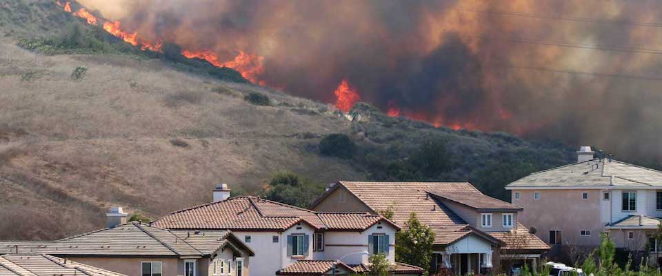
“The scale was astounding,” says Scott Stephens, professor of fire science at UC Berkeley and noted authority on wildfire. “You essentially lost a whole town,” something we haven’t seen since the 19th century. Still, he’s more saddened than surprised by Paradise. “There are so many towns throughout the West and especially in California that are equally vulnerable, including several in the Bay Area.” The most susceptible communities are those located in the so-called wildland–urban interface (WUI), where human development and forests overlap.
Says Stephens, “People living in or near forested areas under-appreciate the threat.”
I DROVE TO PARADISE about a week after the Camp Fire was declared controlled to see the aftermath firsthand.
There are two main roads into town. The Skyway follows the crest of the Butte Creek Canyon palisades, affording arresting views of the adjacent gorges and the Sacramento Valley to the south. But I came in the back way, via Highway 191, which forks north from Highway 70, near Thermalito and Oroville Dam. As the road started to climb from the flats along the aptly named Dry Creek, a demarcation line became visible; beyond it, everything was black.
Paradise had once been a green town—not in any eco-touristic sense, but quite literally; it was practically subsumed by the surrounding forest, a quality that lent support to its heavenly moniker. The town logo was a conifer with a halo around it; people came here to live among the trees.
At a roadblock, a dead-eyed California Highway patrolman checked my press credentials. He was flanked by two National Guardsmen, hands on their pistol butts. A sign that once welcomed visitors (“You Are Ascending into Paradise”) had burned to the ground and was replaced by a crude warning spray-painted on chipboard. “Looters Beware We Have Guns and a Backhoe KEEP OUT!”
When I came into town—well, there was no town. From the car window, the obliteration looked like Ground Zero.
The officer looked at my papers, looked at me, asked for my driver’s license, looked at me again, then handed back my documents.
“Go on,” he said finally. “But be careful up there.”
I was prepared for Paradise. At least, I thought I was. As a young man I’d fought wildfires for several years working on U.S. Forest Service crews in Washington and California. Later, I covered fires for many years as a reporter for the San Francisco Chronicle. Notebook in hand, I asked people wearing thousand-yard stares what they would do next.
Then, in October 2017, the tables very nearly turned.
I live in Santa Rosa where the Tubbs Fire, the most destructive of the North Bay fires, burned through the Coffey Park and Fountaingrove neighborhoods. Our home survived, but I’d had to evacuate my family three times before it was finally declared controlled. We were lucky, but some of our neighbors lost everything.
In short, I knew what fire could do. And yet, I still wasn’t ready for Paradise.
When I came into town—well, there was no town. Just street after street of ash, cinders, and piles of twisted metal and burned-out cars, punctuated by scorched black chimneys, standing upright amid the ruins. As I drove past the destruction, I flashed on grainy images of Hiroshima after the bomb. True, Paradise was a town of 27,000, not an industrialized city of 255,000. But from the car window, the obliteration looked like Ground Zero.
Is this the “new normal” then? It’s just a preview, says Chambers. “We’re only experiencing a fraction of the changes we’re going to experience.”
I saw a guy standing alone contemplating a former shopping complex—at least, I think it was a shopping complex—and stopped to chat. Dillon Sova is a seasonal firefighter with Cal Fire, the state firefighting agency. He hadn’t been on the fire lines for the Camp Fire; he’d come to deliver equipment for the response effort, then lingered to survey the damage.
“I heard it was like a blowtorch in here,” he said. “There was plenty of fuel, the winds were so strong, and wherever they pointed, it burned, and burned fast. Nobody’s seen anything like this.”
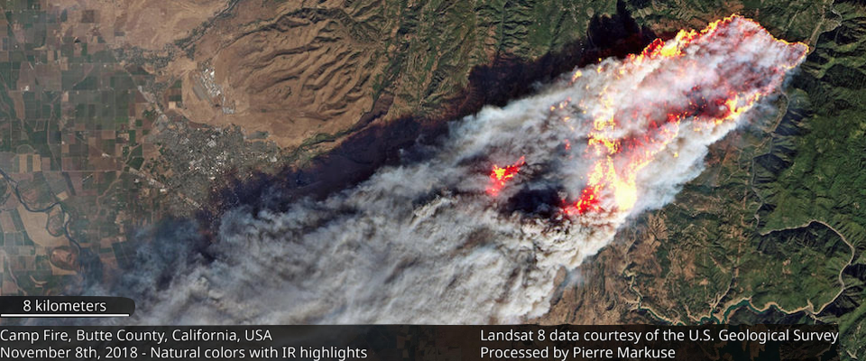
Berkeley geographer Jeffrey Chambers used Google Earth Engine to analyze satellite images of the Camp Fire as it progressed, from its ignition point near high-tension wires running past the tiny town of Pulga, through the Paradise city center. He clocked the speed of the fire at three miles per hour and was able to show how wind-driven embers sparked spot fires up to two and half miles ahead of the flames as the fire raced through the city. “It was a phenomenal rate of speed, particularly in the first hour.”
As to the causes behind the devastation, Chambers points to a number of factors, including fuel types, topography, and changing climate. “For example, the winter rains we’d typically expect seemed delayed by a few weeks this year.” A single storm at the usual time for the area would have reduced the number of potential ignition points, says Chambers. “Even small shifts in the timing and amount and type of precipitation—how much falls as rain and how much as snow—can have huge implications.”
A similar dynamic played out in the Woolsey Fire which was sparked on the same day as the Camp Fire and led to the evacuation of nearly 300,000 people in Los Angeles and Ventura Counties.
“October is the bad month for the wind,” Joan Didion wrote in her famous 1968 essay “Some Dreamers of the Golden Dream” about life in the Southland—“the month when … the hills blaze up spontaneously.” Minus precipitation, November is bad too. And even December. Had the quenching rains come before the Santa Anas, the Woolsey Fire likely would not have happened. As insult atop injury, the rains that come after the fires cause their own destruction in mudslides, like the one that tore through Montecito in the wake of the enormous Thomas Fire.
In 2017, Cal Fire’s fire suppression budget ran to nearly half a billion dollars. Just a month into fiscal year 2018, the state had already spent one-quarter of its firefighting allotment.
Is this the “new normal” then? It’s just a preview, says Chambers. Given the assurance of more warming, “We’re only experiencing a fraction of the changes we’re going to experience.”
WHEN I WAS A FIREFIGHTER in the 1970s and 1980s, really large wildfires were relatively rare occurrences. Crews could go season after season without being dispatched to a truly catastrophic blaze, and most of the big fires that did occur were in Southern California. That was a disappointment to us. We craved big fires because it meant a lot of overtime and excitement. (A certain baseline pyromania is implicit in the firefighting trade.) But my sense is that few of today’s crews feel they aren’t getting enough time on the fire lines.
Where Cal Fire used to keep seasonal firefighters on the payroll for four months—the duration of the “typical” fire season, now many can expect six- and even nine-month appointments. “I’m still working, and I was laid off by this time last year,” Sova told me. “Basically, there’s no ‘fire season’ anymore. At least in parts of the state, the fire season is year-round now.”
“Firefighting at Christmas” is how Governor Brown put it. Ever budget-conscious, Brown reminded Californians that the effort comes at a high price. In 2017, Cal Fire’s fire suppression budget ran to nearly half a billion dollars, and just a month into fiscal year 2018, the state had already spent one-quarter of its firefighting allotment. By September, normally the end of the fire season, the budget was depleted, and the agency requested another $234 million to continue operating.
When President Trump came to Paradise in the wake of the Camp Fire, flanked by Brown and Governor-elect Newsom, he flubbed the town’s name—Pleasure, he called it—then preceded to excoriate state officials for mismanaging California’s forests. It was a theme he had tweeted two days after the fire broke out, when more than a thousand residents still remained unaccounted for: “There is no reason for these massive, deadly, and costly forest fires in California except that forest management is so poor. Billions of dollars are given each year, with so many lives lost, all because of gross mismanagement of the forests. Remedy now, or no more Fed payments!”
“Basically, there’s no ‘fire season’ anymore. At least in parts of the state, the fire season is year-round now.”
Trump, who had just met with the Finnish president, compared California’s forests to Finland’s, which, he insisted, were assiduously raked to reduce fire risks—a bizarre claim that prompted one bemused Finn to post a photo on social media. It showed a solitary figure holding a garden rake. “Not on my watch,” the caption read.
The remarks revealed Trump’s bedrock ignorance, not only of forestry but also geography (Finland is wetter and colder and thus less fire-prone than California) and government (nearly three-fifths of California’s forests are managed by federal, not state, agencies). But he was right about one thing: California’s forests really have been mismanaged. Decades of overzealous fire suppression and excessive clear-cutting, followed by excessive tree planting has resulted in millions of acres of overstocked forests—that is, too many trees crammed into too little space.
When I worked for the Forest Service, the agency was focused on maximizing timber harvests. Fire crews would spend the autumn months burning slash in immense clear-cut units that had been logged in the summer and spring. The trees taken were typically old-growth ponderosa pine and Douglas fir, conifers that had taken centuries to mature. After burning, the units were quickly replanted with Douglas fir seedlings bred for rapid growth. In this way, the Forest Service transformed healthy, diverse forests into vast, overcrowded tree plantations that now function as gigantic fuel reservoirs. When they ignite, they burn explosively.
That was the case in the Rim Fire, California’s fifth largest, which was sparked in August 2013 and burned for more than a year in the Stanislaus National Forest and parts of Yosemite National Park. Much of the heaviest fuel loads in the Rim Fire were located on old logging units that had become overgrown with “doghair thickets” of relatively young trees. This was compounded by vast stands of dead trees killed by drought and bark beetles. (There are an estimated 130 million dead trees in the Sierra Nevada alone.) The result was a fire of unusual intensity, one that burned everything down to mineral earth, resulting in severe, long-term environmental damage in large swaths of the Stanislaus.
“We all love trees, but at a certain point you may decide that a closed-canopy forest isn’t really a good idea for a residential neighborhood.”
Yosemite fared better, thanks to aggressive fuel-reduction efforts by the National Park Service, including tree thinning and controlled burns to clear detritus from the forest floor (Trump’s rake idea, basically, but using a more realistic and efficient tool).
As the Rim Fire story suggests, more of this is needed—much more. According to a recent state study, only about 261,000 acres of California forest get treated annually, and even doubling that figure would do little more than maintain current “historic rates of burning.” To actually reduce destruction by wildfires, we’d have to ratchet up fuel reduction considerably. And that requires money.
Costs of fuel treatment can vary from a few hundred to several thousand dollars per acre, depending on terrain, accessibility, and other factors. In Oregon’s Deschutes National Forest, which has a long history of prescription burning, costs typically run $250 an acre. Using that as a rough guide, it would cost nearly $5 billion to treat the state’s 19 million acres—once. And since trees and underbrush grow back, once is not enough. The effort must be ongoing.
Mechanical thinning (think chainsaws), is even more costly than prescribed burning. It is also contentious. As Berkeley Professor J. Keith Gilless says, “It’s always going to be a complex and nuanced discussion. We all love trees, but at a certain point you may decide that a closed-canopy forest isn’t really a good idea for a residential neighborhood.” He adds that judicious logging can “make a landscape more resilient” while reducing post-fire erosion and risks to power lines.
“Mechanical thinning is strictly a cost issue,” Gilless notes, “so we need to develop benefits, such as the utilization of biomass”—that is, turning wood from thinning into electricity.
Scott Stephens insists that smoke is a natural feature of California life. Our forests are “fire-adapted,” meaning that many native trees require low-level fire to thrive.
The push for thinning and fuel reduction often gets misinterpreted, however, especially on the political fringes, where it is seen, favorably or not, as a call for more clear-cutting. But Kristen Shive, a senior scientist and fire ecologist with Save the Redwoods League [full disclosure: I sometimes write for Save the Redwoods publications], cautions that, while “timber harvests—done well, in certain places—can have a role in the solution, that doesn’t mean we should open vast areas to logging.” For starters, says Shive, who earned her Ph.D. from UC Berkeley in 2017, “large trees are not the ones that are causing our fuels problems. It’s the smaller diameter trees that create fuel continuity which need to be dealt with. You can remove those with mechanical thinning, but in many areas, neither logging nor mechanical thinning is practical because of inaccessibility.”
Which brings us back to fire as the best tool for large-scale fuel reduction.
While preventing fire with fire may sound perverse, especially given the effects of smoke on air quality, Shive stresses that it’s not an either/or proposition. The forests will burn—it’s just a matter of when. And fire suppression has only worsened the problem by allowing fuels to accumulate. “We’ve basically banked a lot of smoke on the landscape, and one way or another it will be spent. It can be released slowly, or it can be released catastrophically,” as was the case, post-Paradise when the air quality in much of Northern California became more hazardous than Beijing’s and Delhi’s.
In many cases, Shive says, “we should let fires burn in the late fall,” when conditions for control are optimal. “We lose opportunities for significant fuel reduction when we put them out at those times. An area that might burn severely in August might be OK to burn in November.”
For his part, Scott Stephens insists that smoke is a natural feature of California life. Our forests, he says, are “fire-adapted,” meaning that many native trees require low-level fire to thrive. He adds that the state’s air was smoky long before European settlers arrived. Fires were common from late spring through autumn due to lightning strikes and deliberate ignition by indigenous people to clear brush, encourage the growth of food plants, and allow for easier hunting.
The push for thinning and fuel reduction often gets misinterpreted, especially on the political fringes where it is seen as a call for more clear-cutting.
“We published a paper in 2007 that analyzed [pre-Columbian] wildfires in California, and we estimated that about 4.5 million acres burned annually,” says Stephens. For comparison, in 2007, wildfires burned just 1.5 million acres in the state. The pre-settlement fires would have been much lower intensity, precisely because fire regularly scoured the landscape. They burned through forests characterized by large, well-spaced trees with scant understories.
IN CHICO AFTER THE FIRE, in the taproom at the Sierra Nevada Brewing Co., the talk around the bar was of rebuilding. Much of the staff, including the bar manager, the bartender, and a few of the servers had lost their homes to the Camp Fire, and while some former Paradise residents were already locating elsewhere, the bar staff were mostly intent on moving back home, whatever it took.
That spirit is certainly admirable. It may not be wise.
Whatever else you might say about it, Paradise is fire-prone. According to an analysis by the Bay Area News Group, 13 large wildfires have occurred in the Camp Fire perimeter in the last 20 years. In 2008 alone, two major fires burned on either side of city boundaries: the sizable Humboldt Fire just to the west of town and the truly massive Butte Lightning Complex fires to the east. While that fire didn’t jump the Feather River and burn into heavily populated areas, it nevertheless forced the evacuation of some 10,000 Paradise residents.
According to local lore, the town was originally called Pair o’ Dice, a name that harks back to Old West gambling roots. And, though likely apocryphal, it now seems apt, for whether or not residents fully appreciated it, life there was a gamble.
Paradise is hardly alone in that. Many Californians are making the same bet. Consider Santa Rosa, where new homes are going up in Fountaingrove, the upscale enclave that burned during the Tubbs Fire.
UC Berkeley has proposed removing more eucalyptus, but the effort has met considerable resistance from local “tall trees” advocates.
Situated along a ridgetop overlooking the city, the slopes leading up to the neighborhood are punctuated by arroyos that serve as chimneys, funneling and accelerating fire upward. A blaze in 1964 followed virtually the same path as the Tubbs Fire, but relatively few homes were lost then as development was still sparse. Given the area’s propensity to burn, it seems foolhardy to allow rebuilding, but Santa Rosa city planners say they are powerless to stop the construction and the city needs the tax revenue.
According to the U.S. Forest Service, about 4 million California homes, or roughly 30 percent of the total, were in the fire-susceptible Wildland–Urban Interface as of 2010. From the Berkeley campus, you needn’t look far for examples; a glance toward the hills will suffice. Here too, the Diablo winds can whip up flames and wreak havoc, as indeed they often have in the past (see “When Berkeley Burned“).
In August 2017, a small grass fire broke out on Grizzly Peak Road near the Berkeley Lab, and was quickly extinguished. Fortunately, the wind was blowing from the west that day, away from Lab and campus. Still, just the smoke on the ridgeline was enough to raise the specter of the Oakland Hills Fire of 1991 that killed 25 people. As Berkeley Lab Fire Marshal Todd LaBerge later told the Lab’s internal news outlet, “If 50–60 mph winds are blowing a Tilden Park wildfire west toward the Bay, we’d have 30 seconds to get out. You’d still be looking for your keys and the firewall would have come past you.”
Due to the extreme hazard in the East Bay Hills, Scott Stephens has pushed for more treatment efforts there. He points to areas where fire-resistant oak woodlands have replaced more flammable stands of eucalyptus. According to Stephens, “The blue gum eucalyptus forests on the ridges in the upper one-third of the East Bay Hills are the most hazardous fuels in the area” as they “produce a great deal of dead and downed fuels, especially bark that comes off in long sheets. Those sheets can be transported downwind and start spot fires miles ahead of the fire front during high east winds.”
For that reason, UC Berkeley has proposed removing more eucalyptus, but the effort has met considerable resistance from local “tall trees” advocates who, so far, have been successful in halting further eucalyptus removal through legal action.
The forests will burn—it’s just a matter of when. And fire suppression has only worsened the problem by allowing fuels to accumulate.
AS MORE FOLKS SETTLE IN THE WUI, firefighting is also is being forced to change.
I recall responding to a cabin fire when I was with the Forest Service. None of us really knew what to do, so we dug line around it and watched it burn.
These days, state wildfire crews are trained to protect homes and structures, as well as contain forest fires. Scott McLean, a deputy chief with Cal Fire’s Communications Office, says the agency now has an entire mock city to teach urban firefighting.
Homeowners shouldn’t rely on firefighters to save them, however. It’s their responsibility to take all sensible precautions. For decades, Cal Fire has emphasized the necessity of maintaining defensible space around structures in wildland areas. That means the removal of trees, brush, and high grass around homes. Not long ago, 30 feet of defensible space was considered adequate. But in 2008, the agency updated its fire codes, adding fire-resistant standards for windows, decks, and roofs in WUI areas to a 2005 standard of 100 feet of defensible space around structures. It’s safe to say that very few homes currently meet those standards.
Of course, when miles of countryside suddenly explode in flames, talk of standards and solutions become mere abstractions. All one can do is flee. But driving around the rubble that was Paradise, where cars were abandoned on the roadside in the chaos of evacuation, it’s clear there was little real chance of escape for anyone caught in the blowtorch.
SHORT OF SOME MIRACULOUS REVERSAL of global warming—through, say, atmospheric carbon removal on an epic scale via as-yet-undeveloped technology—California and the intermountain West are going to endure more fires like the one that destroyed Paradise. The best we can do is take steps to adapt and prepare for the worst. Thankfully, the State of California is already making such moves, most recently with the introduction of Senate Bill 46. Introduced by Hannah-Beth Jackson (D-Santa Barbara), it would bolster emergency notification systems.
And Berkeley’s Jeffrey Chambers thinks his satellite imagery work may also yield more accurate and timely information on fire behavior. “If you can do rapid, even real-time analyses on developing fire situations, it could be immensely useful to the public,” he says. “But,” he adds, “if people want real information on this and other climate change impacts, it’ll take funding. You can’t lowball it.”
Don Peck is also adapting. Or trying to. With no home, no family—not even his cat—he’s been staying with friends in Oakland. With his health issues and limited income, his position is unenviable, but he remains upbeat despite it all.
“Truthfully, it’s pretty meager living at this point,” he says. “But I have a roof over my head and I’m staying with nice people. And what’s really been amazing is that my old Cal fraternity brothers from Theta Delta Chi heard about me and stepped right up to help me out—everything from money, to clothes, to taking me out to lunch. I haven’t heard from some of those guys in 50 years.
“I look back on this, and yes, it’s been a tragedy. It was a disaster. But I was able to save a man from dying by giving him a ride when I evacuated. I was taken care of when I was sick and cold at Enloe Hospital. Friends have given me places to stay. … I’ve been overwhelmed by human kindness, and I know I’m not the only one. Some good has come of this.”
Glen Martin is a frequent contributor to California and California Online.
From the Spring 2019 issue of California.


